


A new online tool is being praised by researchers and climatologists, as the Canada-wide Climate Atlas was released last Wednesday.
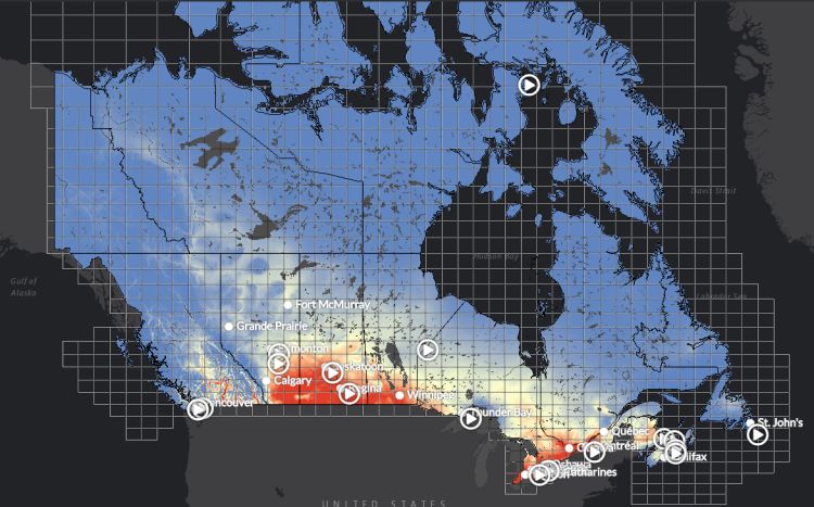
Encompassing all of Canada, this new interactive tool shows Canadians just how climate change would affect their cities, including Moose Jaw, over the next 80 years.
"We had the ability to do something that had never been done before, certainly not for Canada and we think it's unique in the world and we're hearing from people, well respected climatologists for example that, you know, there's nothing like this in the United States," said Danny Blair, the Director of Science for the Prairie Climate Centre at the University of Winnipeg. "The United States has lots of good resources about climate change online and elsewhere but this is a first of a kind, certainly for Canada."
A huge team of researchers, scientists, film makers, designers, and computer coders worked together to bring this to the public, but, the map itself had some small beginnings, only covering three provinces.
"About three years ago, we created a "Prairie Climate Atlas," Blair explained. "Which just covered, as you can tell, the prairie provinces - all of Alberta, Saskatchewan, Manitoba, on which we were able to provide people easy access or relatively easy access to data kind of in their own backyard and as soon as we posted that atlas online we realized everyone needed to see something like this."
The map is available online at anytime. It spans in details involving info on high and low carbon outcomes for the future, precipitation levels, and how many plus and minus thirty days cities could experience over 70 years from now. It is also highly interactive, and shows videos on how municipalities around Canada are fighting climate change.
Below, you can listen to Blair describe more about the map, his team, and what the information means.


 Sat, May 18, 9:00 AM
 Casual, Administrative, Retail

 Featured


